


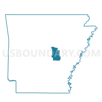
MAGNESS Voting District, Lonoke County, Arkansas
About
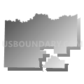
Outline

Summary
| Unique Area Identifier | 527219 |
| Name | MAGNESS Voting District |
| County | Lonoke County |
| State | Arkansas |
| Area (square miles) | 20.20 |
| Land Area (square miles) | 20.08 |
| Water Area (square miles) | 0.12 |
| % of Land Area | 99.43 |
| % of Water Area | 0.57 |
| Latitude of the Internal Point | 35.04047300 |
| Longtitude of the Internal Point | -92.06057060 |
Maps


Graphs
Select a template below for downloading or customizing gragh for MAGNESS Voting District, Lonoke County, Arkansas


Neighbors
Neighoring Voting District (by Name) Neighboring Voting District on the Map
- Voting District 26, Pulaski County, AR
- CABOT WARD 2, Lonoke County, AR
- East Cypress Voting District, Faulkner County, AR
- El Paso Voting District, White County, AR
- Royal Voting District, White County, AR
- WARD TWP RURAL Voting District, Lonoke County, AR
- YORK Voting District, Lonoke County, AR
Top 10 Neighboring County Subdivision (by Population) Neighboring County Subdivision on the Map
- Hill township, Pulaski County, AR (162,764)
- York township, Lonoke County, AR (22,085)
- Cypress township, Faulkner County, AR (5,480)
- Magness township, Lonoke County, AR (5,084)
- Ward township, Lonoke County, AR (4,508)
- Royal township, White County, AR (703)
- El Paso township, White County, AR (691)
Top 10 Neighboring Place (by Population) Neighboring Place on the Map
Top 10 Neighboring Unified School District (by Population) Neighboring Unified School District on the Map
- Pulaski County Special School District, AR (152,855)
- Cabot Public Schools, AR (48,187)
- Beebe School District, AR (17,431)
- Vilonia School District, AR (14,891)
Top 10 Neighboring State Legislative District Lower Chamber (by Population) Neighboring State Legislative District Lower Chamber on the Map
- State House District 48, AR (41,391)
- State House District 47, AR (34,367)
- State House District 42, AR (32,375)
- State House District 49, AR (32,244)
Top 10 Neighboring State Legislative District Upper Chamber (by Population) Neighboring State Legislative District Upper Chamber on the Map
Top 10 Neighboring 111th Congressional District (by Population) Neighboring 111th Congressional District on the Map
Top 10 Neighboring Census Tract (by Population) Neighboring Census Tract on the Map
- Census Tract 710, White County, AR (7,016)
- Census Tract 201.01, Lonoke County, AR (6,749)
- Census Tract 303.02, Faulkner County, AR (5,622)
- Census Tract 34.04, Pulaski County, AR (5,014)
- Census Tract 303.03, Faulkner County, AR (4,387)
- Census Tract 202.01, Lonoke County, AR (3,729)